Southern Marlborough is the country you travel through after leaving Blenheim for Kaikōura: the lower Awatere vineyards, Seddon, the salt-producing lake at Grassmere and the farming settlement of Ward. The coast here is exposed to the Pacific, quite different from the enclosed-looking bays of the Sounds. It rewards a slower day with a picnic, a beach stop and time to understand the working landscape.
Seddon is the service point for the lower Awatere Valley, while Ward is the useful overnight choice farther south. Marfells Beach is reached on a side road beside Lake Grassmere, not directly from SH1. The upper Awatere and the Molesworth high-country route are a separate travel decision, with significant current restrictions. This guide keeps those distinctions clear so a scenic drive does not become an unexpected remote-road commitment.
Quick take
Allow: a relaxed day from Blenheim, or an overnight at Ward or a booked Marfells campsite before continuing to Kaikōura. Best for: rural scenery, an uncrowded-feeling coastal visit and a change from town and winery touring. Important: the current upper Awatere closure prevents a through-drive to Molesworth; Sawcut Gorge is also under a stay-away hazard notice. Read the Marlborough regional guide for the broader route.
Seddon and the lower Awatere Valley
Seddon lies south of Blenheim near the Awatere River crossing. It serves a farming and wine-growing district rather than a compact visitor precinct. Use it to buy supplies, check the route and pause before choosing a side road. You will see vineyard blocks mixed with the wider rural landscape, with bigger hills behind the valley.
The Awatere is a separate wine area from the Wairau Valley west of Blenheim. A landscape of vineyards does not mean every winery has a public cellar door. For tastings, book actual visitor arrangements or use the established Wairau options in our Blenheim and wine country guide. For an Awatere visit, a measured drive on confirmed-open public roads can be the experience in itself.
Do not drive down a private vineyard lane to get a better photograph. Choose lawful stopping places with room to pull fully off the road, keep gates and accessways clear, and let farm or vineyard vehicles pass. If you want to go farther up the valley, check the exact road segment rather than relying on a generic map showing an unbroken line to Hanmer Springs.
Lake Grassmere / Kapara Te Hau and the saltworks landscape

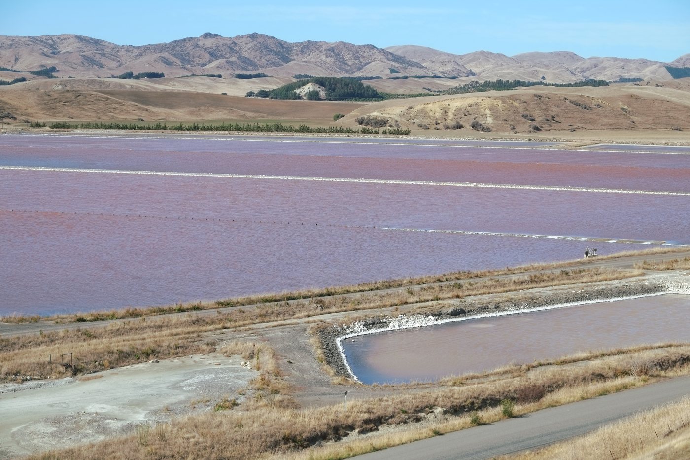
Lake Grassmere is used for solar salt production, with evaporation and crystallisation ponds laid out beside the coast. Light, season and operations affect what you see; pink ponds are not a guaranteed daily spectacle. The combination of shallow water, salt and dry hills makes this a distinctive southern Marlborough landscape without needing access inside the plant.
The East Coast Heritage Trail gives historical context for the lake and neighbouring settlements and explicitly notes that the saltworks site has no public access. Keep that boundary clear. Follow public roads and any designated visitor signs, and only stop where parking is safe and permitted. Do not walk into operating areas, across pond banks or on railway land to recreate a photograph.
Kapara Te Hau is the Māori name associated with the lake. The wider southern coast and river valleys have longstanding Māori histories of travel, settlement and gathering food, as well as later pastoral and industrial development. Use local heritage interpretation and iwi accounts for context; archaeological or cultural importance is not permission to collect objects or enter restricted land.
Marfells Beach: a coastal outing or an overnight
Marfells Beach Road runs from SH1 along the southern side of Lake Grassmere to the coast. DOC’s Marfells Beach campsite information describes an approximately 8 km access road from the highway, mostly sealed with a short unsealed section and a steep descent near a bridge. Check road notices and vehicle suitability, especially with a longer campervan or trailer. Allow extra time rather than treating it as a quick pull-off.
A shore visit can be as simple as a picnic and a short walk, choosing the turnaround according to wind, waves and the group. This is an exposed coast, with cold water and changing conditions. Keep children close, leave space around wildlife and use current advice before considering swimming. A quiet beach is not automatically a patrolled or suitable swimming beach.
The DOC campground has non-powered sites, toilets and cold showers. Book ahead under the current online system: DOC says no spaces are held for people arriving without a booking. The two booking zones suit different vehicle shapes, so check the site map and dimensions. Bring the food, water and equipment you need, take all rubbish and food scraps out, and plan your next dump station rather than assuming one is provided. Dogs and fires are not allowed.
Longer shoreline journeys towards Cape Campbell require separate tide, access and conditions planning. They are not included in this simple family outing. A headland that looks close can mean a long return, restricted access or being cut off by the sea. Use an official route and current local advice if that longer walk is the reason for your visit.
Ward, Flaxbourne history and coastal stops
Ward is a useful place to break the southbound journey, with services and accommodation close to SH1. The Flaxbourne name recalls the large pastoral run whose later subdivision helped shape the settlement. The Flaxbourne Heritage Centre on Ward Street provides a specific reason to stop. The trust formed after the 2016 earthquake destroyed the old Ward Museum; the new centre brings the district’s stories together again. Check its current opening days before making it your wet-weather plan. The East Coast Heritage Trail adds context for the surrounding settlements.
For the coast near Ward, confirm the current public road access, parking and signs before heading out. A short beach visit can work in settled weather, but exposed shore, wildlife and private farmland limit where you should go. Leave seals undisturbed, keep well back and never block their route to the water. Choose a lawful shore viewpoint rather than scrambling across rocks to approach animals.
If a coastal road is restricted or the weather is unpleasant, keep the visit to town, heritage information and a warm meal or picnic indoors at your accommodation. You do not need a challenging beach walk to justify staying overnight. The practical benefit is arriving in Kaikōura with time for an activity rather than after an overfilled day.
Upper Awatere, Molesworth and Sawcut: current exclusions
The current Awatere Valley Road closure notice, updated 4 November 2026, says the road at Cam Corner, 10.5 km up-valley from Jordan Bridge, remains closed to all traffic because of unstable slip material and recovery work. There is no through access from the Awatere Valley to Molesworth. Earlier reopening hopes are not a confirmed opening. Follow the live notice and barriers rather than assuming a midday works gap allows tourist access.
DOC’s Acheron Road guidance explains the separate high-country route, normal seasonal arrangements and vehicle restrictions. Its general description does not override the approach-road closure. Access from the Hanmer side is a different journey requiring its own DOC check and return plan, not a detour to add to this Marlborough day. Rental permission, remote supplies and unsealed-road experience matter even when a route is open.
The council’s Sawcut Gorge hazard notice, dated 23 October 2026, asks people to stay away from Sawcut Gorge and the Waima River valley near Isolated Hill Scenic Reserve because of rockfall and an unstable river dam. This is not a place to improvise a visit or assess the hazard yourself. The gorge is excluded from the suggested plans. Refresh these dated notices before travel; they describe current hazards, not permanent geography.
Where to stay and how to plan food
A motel night in Ward: Flaxbourne Motel & Camp Ground is a specific self-catering option. Its queen and twin studios sleep two; one-bedroom units include separate four- and five-person configurations. The provider lists a kitchenette with a full oven in the motel units. Check the exact beds: some are in the lounge rather than a second bedroom.
A simpler cabin or camping stay: Flaxbourne also lists queen-bed cabins with shared facilities and basic in-room refrigeration and hot-drink equipment. Confirm campground availability, vehicle fit, cooking access and arrival arrangements directly. A cabin is a different product from the motel unit with its own cooking facilities.
A beach night: the booked Marfells DOC campsite suits equipped campers who value being by the coast and accept wind and basic facilities. It is not the substitute for a heated motel room on a stormy night. For a larger range of hotel, family-room and restaurant options, stay in Blenheim and make southern Marlborough a day trip.
For a named food stop, MJ’s Services Café at Ward lists café meals and baking beside its SH1 service station. Check kitchen hours separately from fuel availability; a late petrol stop is not a promise of dinner. Buy picnic supplies in the main towns and confirm what is open in Seddon or Ward on your travel day. The selection is smaller than Blenheim’s, and a shop or fuel stop does not guarantee a late dinner service. Having a motel kitchen is particularly useful here. Carry enough fuel for the planned side trip and return; fuel availability and opening hours should be checked before extending the route.
A relaxed day trip and a southbound overnight
One day from Blenheim
Day 1 — lower valley, lake and coast. Start and finish: Blenheim. Allow about 20–30 minutes to Seddon and roughly 45–60 minutes to Ward by SH1 before stops. Choose a modest lower-valley look, a lawful view of the Lake Grassmere landscape and a short Marfells visit if conditions suit. The beach access adds time in each direction. Take a picnic and return before fatigue turns the last part into a rush. The upper Awatere and Sawcut are not alternatives on this plan.
Two days towards Kaikōura
Day 1 — southern Marlborough at a slower pace. Start: Blenheim. Overnight: Ward or booked Marfells Beach. Use the day-trip choices, with time to settle into the overnight. Confirm food and arrival arrangements before leaving town. Camp only if the weather and your equipment make it sensible.
Day 2 — continue down the coast. Finish: Kaikōura. From Ward, allow roughly 1¼–1½ hours of driving before stops and works; from Marfells, add the return to SH1 and the northern part of the approach. Leave room for a break and plan any wildlife tour separately around its actual check-in. The Kaikōura guide explains responsible wildlife options and weather backups.
Driving, costs and onward planning
Use NZTA Journey Planner for SH1, Weld Pass and the coastal highway, with Marlborough District Council alerts for side roads. These driving allowances are for planning, not live traffic predictions. Heavy rain, slips, roadworks and exposed coastal weather can change the day. Avoid inventing a cross-country shortcut when your planned road is closed.
Most of this guide is about ordinary public-road travel, lawful viewpoints and short outings. Accommodation, camping and food are the main additional costs, with current fees shown by the providers. Read Marlborough’s responsible-camping rules before choosing any overnight outside a booked campground; a quiet reserve is not automatically a legal campervan site.
Return to the regional hub for the wider route. Picton and Queen Charlotte Sound, Havelock and Kenepuru and the Queen Charlotte Track need their own days rather than being added to the same southbound drive. Our driving in New Zealand guide and 14-day South Island campervan itinerary help with the larger South Island journey.